Property Record
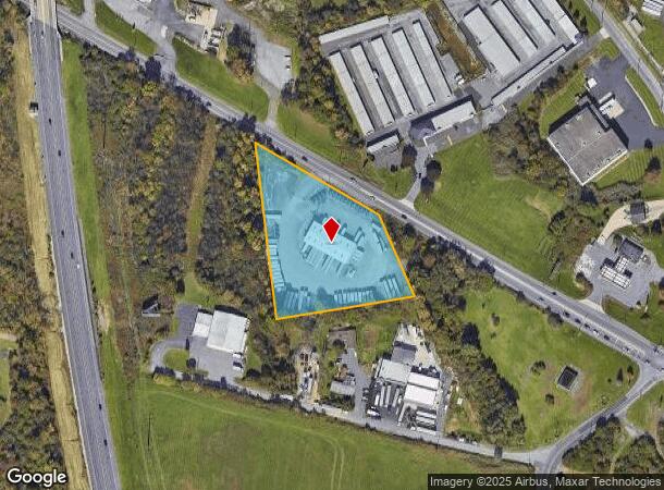
1940 Pa Route 309, Allentown, PA 18104
NEARBY LISTINGS FOR SALE OR LEASE
Property Detail
1940 Pa Route 309
547723463693-1
LOTS: 002
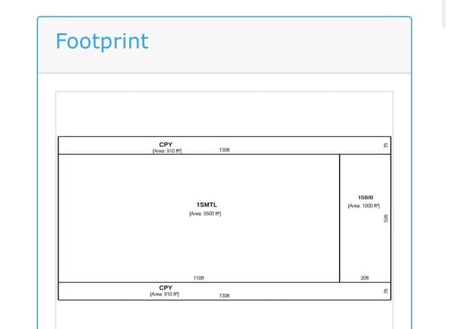
Warehouse
Lehigh
X
Pennsylvania
42011C0250G
2
2025
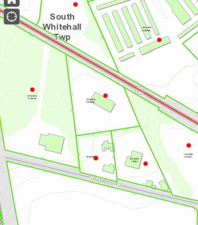
3.05 AC
2025
Lehigh Valley
006002
Philadelphia
6,500 SF
Allentown-Bethlehem-Easton, PA-NJ
DEMOGRAPHICS near 1940 Pa Route 309
1 Mile
3 Mile
5 Mile
2024 Total Population
2,573
34,095
124,811
2029 Population
2,614
34,476
125,760
Pop Growth 2024-2029
+ 1.59%
+ 1.12%
+ 0.76%
Average Age
42
42
41
2024 Total Households
967
13,035
47,021
HH Growth 2024-2029
+ 1.65%
+ 1.10%
+ 0.75%
Median Household Inc
$98,065
$97,745
$73,754
Avg Household Size
2.70
2.50
2.50
2024 Avg HH Vehicles
2.00
2.00
2.00
Median Home Value
$354,249
$337,450
$279,061
Median Year Built
1982
1983
1972
Nearby Places
Map Layers
Map Styles
 Street
 Aerial
- Restaurants
- Banks
- Shops
- Fitness
- Groceries
PUBLIC TRANSPORTATION
AIRPORT
Lehigh Valley International
DRIVE
WALK
Distance
Lehigh Valley International
17 min
10.2 mi
Freight Ports
Port of Philadelphia
DRIVE
WALK
Distance
Port of Philadelphia
77 min
59.7 mi
SALE & LEASE HISTORY
LISTING DATE
SALE/LEASE

Jan 08, 2024
For Sale
Nearby Properties
Address
Land Use
TOTAL SIZE
Lot Size
Zoning
Address
Land Use
TOTAL SIZE
Lot Size
Zoning
74,985 SF
112.49 AC
RR-2
Address
Land Use
TOTAL SIZE
Lot Size
Zoning
58,613 SF
26.22 AC
HC-1
Address
Land Use
TOTAL SIZE
Lot Size
Zoning
225,102 SF
20 AC
HC
Address
Land Use
TOTAL SIZE
Lot Size
Zoning
28,911 SF
35.36 AC
GI
Address
Land Use
TOTAL SIZE
Lot Size
Zoning
640,041 SF
155.76 AC
IC-1
Address
Land Use
TOTAL SIZE
Lot Size
Zoning
480,000 SF
27.94 AC
LI
Address
Land Use
TOTAL SIZE
Lot Size
Zoning
91,706 SF
17.27 AC
HC-I
Address
Land Use
TOTAL SIZE
Lot Size
Zoning
244,481 SF
30.24 AC
LI
Address
Land Use
TOTAL SIZE
Lot Size
Zoning
222,783 SF
49.47 AC
R-3
Address
Land Use
TOTAL SIZE
Lot Size
Zoning
214,790 SF
12.09 AC
GC-1
Address
Land Use
TOTAL SIZE
Lot Size
Zoning
525,868 SF
32.38 AC
LI
Address
Land Use
TOTAL SIZE
Lot Size
Zoning
28,897 SF
33.79 AC
HC-I
Address
Land Use
TOTAL SIZE
Lot Size
Zoning
11,850 SF
32.34 AC
R-ML
Address
Land Use
TOTAL SIZE
Lot Size
Zoning
523,123 SF
38.24 AC
LI
Address
Land Use
TOTAL SIZE
Lot Size
Zoning
170,208 SF
41.45 AC
R-3
Address
Land Use
TOTAL SIZE
Lot Size
Zoning
112,200 SF
25.05 AC
LI
Address
Land Use
TOTAL SIZE
Lot Size
Zoning
3,245 SF
10.56 AC
R-MP
Address
Land Use
TOTAL SIZE
Lot Size
Zoning
12,233 SF
18.30 AC
R-MP
Address
Land Use
TOTAL SIZE
Lot Size
Zoning
11,966 SF
134.70 AC
AR-I
Address
Land Use
TOTAL SIZE
Lot Size
Zoning
79,400 SF
4.10 AC
GC-1
Address
Land Use
TOTAL SIZE
Lot Size
Zoning
100,752 SF
18.17 AC
GC
Address
Land Use
TOTAL SIZE
Lot Size
Zoning
13,660 SF
11.59 AC
R-MH
Address
Land Use
TOTAL SIZE
Lot Size
Zoning
352,946 SF
19.83 AC
LI-B
Address
Land Use
TOTAL SIZE
Lot Size
Zoning
141,550 SF
32.12 AC
IC-1
Address
Land Use
TOTAL SIZE
Lot Size
Zoning
18,679 SF
12.11 AC
R5
Address
Land Use
TOTAL SIZE
Lot Size
Zoning
266,850 SF
41.93 AC
LI
Address
Land Use
TOTAL SIZE
Lot Size
Zoning
197,565 SF
32.95 AC
IC-1
Address
Land Use
TOTAL SIZE
Lot Size
Zoning
240,747 SF
30.64 AC
LI
Address
Land Use
TOTAL SIZE
Lot Size
Zoning
123,740 SF
16.95 AC
B-4
Address
Land Use
TOTAL SIZE
Lot Size
Zoning
22,464 SF
60.41 AC
HC
The World's #1 Commercial Real Estate Marketplace
Connect with us
© 2025 CoStar Group
The information above has been obtained from sources believed reliable. While we do not doubt its accuracy we have not verified it and make no guarantee, warranty or representation about it. It is your responsibility to independently confirm its accuracy and completeness. Any projections, opinions, assumptions, or estimates used are for example only and do not represent the current or future performance of the property. The value of this transaction to you depends on tax and other factors which should be evaluated by your tax, financial, and legal advisors. You and your advisors should conduct a careful, independent investigation of the property to determine to your satisfaction the suitability of the property for your needs.